

Description
Product Overview
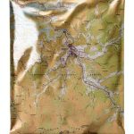
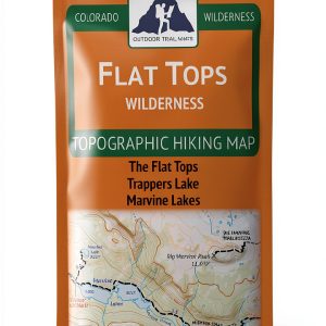
The Butler Maps G1 Series MP 113 topographic map is a meticulously crafted cartographic tool designed for serious outdoor explorers. Produced by Butler Maps, a trusted name in map publishing since 2011, this map presents a full‑color representation of terrain across a compact 9 x 4 inch sheet, making it easy to carry in a pocket or backpack. The paper stock is a lightweight yet robust 0.3‑inch thick material that resists tearing and moisture, ensuring the map remains legible even after a day of rugged use. Detailed contour lines illustrate elevation changes, while clearly marked trails, water sources, and landmarks provide essential navigation cues. The map’s dimensions (9 x 4 inches) and weight (approximately 0.01 kilograms) strike a balance between portability and readability, allowing users to unfold the sheet for a comprehensive view without sacrificing convenience. Every element—from the color palette to the typography—is optimized for quick reference, helping hikers, campers, and backcountry travelers make informed decisions on the trail.
![[Product front view showing all components]](https://www.akvex.store/wp-content/uploads/2026/06/461de233d290435996912b30c0f4a9f1.jpg)
Usage
Designed for a wide range of outdoor activities, the MP 113 map excels in scenarios where accurate terrain data is critical. Whether you are planning a weekend hike in the mountains, a multi‑day backpacking trip, or a casual day trek through a local park, this map provides the spatial context needed to navigate safely. The full‑color design enhances visual contrast, allowing users to distinguish between forested areas, open fields, and water bodies at a glance. Its compact size makes it ideal for inclusion in a daypack, waist belt, or even a pocket‑sized notebook, ensuring that you have reliable reference material on hand without adding bulk. The map also serves as a valuable resource for outdoor educators, trail‑maintenance crews, and emergency responders who require precise geographic information in a portable format. By integrating the MP 113 map into your preparation routine, you can reduce the risk of getting lost, improve route planning, and enhance overall confidence during your adventure.
Why Choose Us
Choosing Butler Maps means selecting a partner committed to quality, accuracy, and customer satisfaction. Each G1 Series map undergoes a rigorous verification process that includes cross‑checking with satellite imagery, on‑the‑ground surveys, and peer review by experienced cartographers. This ensures that the topographic data reflects the most current landscape features, including recent trail modifications and newly established campsites. Butler Maps also invests in sustainable printing practices, using eco‑friendly inks and recyclable paper to minimize environmental impact. In addition to product excellence, the company offers responsive after‑sales support, providing assistance with map interpretation, replacement requests, and guidance on complementary navigation tools. Customers benefit from a community of outdoor enthusiasts who share tips, route ideas, and feedback, fostering a collaborative environment that continuously improves the map series. When you purchase the MP 113 map, you receive not only a reliable navigation aid but also the assurance of a brand that stands behind its products with a dedicated warranty and ongoing updates.
Key Features
- Compact 9 x 4 inch full‑color format that fits easily in any pocket or pack, providing on‑the‑go reference.
- High‑resolution contour lines and elevation markers deliver precise terrain understanding for safe route planning.
- Durable lightweight paper resists tears and moisture, ensuring readability after a full day of outdoor activity.
- Clear trail, water source, and landmark symbols help users quickly identify critical navigation points.
- Dedicated customer support and a satisfaction guarantee give peace of mind and reliable after‑sales service.
FAQ
What is the best way to protect the map from water damage?
While the MP 113 map uses moisture‑resistant paper, we recommend storing it in a waterproof pouch or zip‑lock bag during rainy conditions. Rolling the map loosely inside a dry sleeve before placing it in a pack also helps prevent water from seeping into the fibers. If the map does become damp, gently pat it dry with a soft cloth and allow it to air out before use.
Can I use this map with a GPS device?
Yes, the MP 113 map is designed to complement digital navigation tools. You can overlay the printed map with GPS coordinates by aligning known landmarks or trail intersections. Many hikers use the map as a backup to verify GPS readings, especially in areas where satellite signals may be intermittent.
How often is the map updated?
Butler Maps releases updates to the G1 Series whenever significant changes are identified, such as new trail segments, closures, or alterations in land management. Customers who own previous editions can request a discounted upgrade, ensuring they always have the most current information for safe navigation.
Is the map suitable for winter backcountry travel?
The topographic details, including contour lines and elevation data, remain valuable in winter conditions. However, users should be aware that snow cover can obscure trail markers and water sources. Pairing the MP 113 map with seasonal knowledge, snowpack assessments, and appropriate winter gear is essential for safe winter travel.
Reviews
There are no reviews yet.