

Description
Product Overview
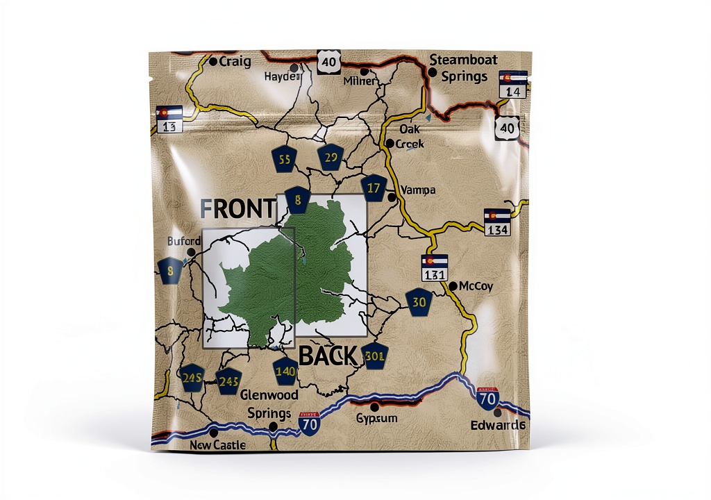
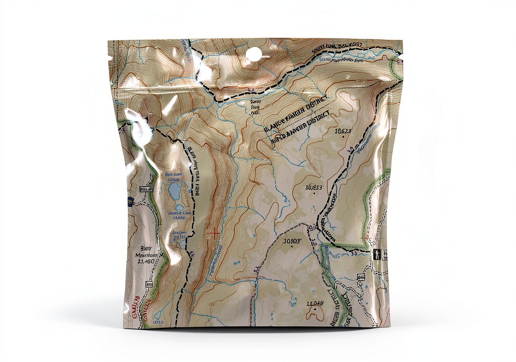
The Outdoor Trail Maps topographic trail map is engineered for the modern adventurer who demands precision, durability, and portability. Measuring just 4 × 7 inches when folded, it easily fits into a pocket, backpack pocket, or even a shirt pocket, allowing hikers to keep essential navigation tools at hand without the bulk of traditional large‑format maps. The map is printed on a high‑quality, full‑color paper that resists tears and water, ensuring that critical information remains legible even after exposure to rain, sweat, or accidental spills.
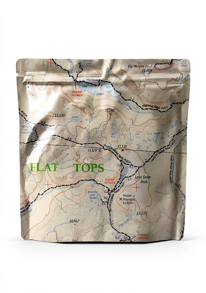
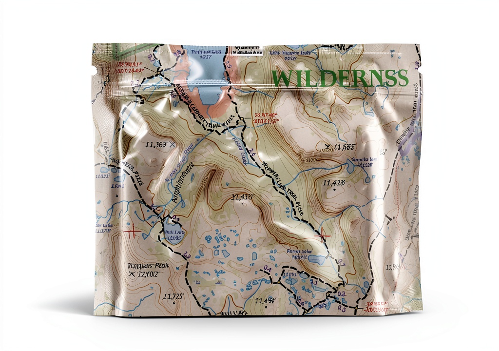
Designed with a 1:60,000 scale, the map provides a detailed representation of terrain features, trailheads, junctions, and elevation changes. This scale strikes a balance between broad coverage and fine detail, giving users the ability to plan day hikes, multi‑day treks, and off‑trail explorations with confidence. Every trail segment is annotated with mileage, allowing hikers to gauge distance and time requirements accurately, while GPS coordinates for trailheads and key junctions enable seamless integration with handheld GPS devices or smartphone navigation apps.
Updated for the 2018 season, the map reflects the latest trail routings, newly established paths, and recent changes to existing routes. The cartographic team at Outdoor Trail Maps LLC conducted extensive field verification, cross‑referencing satellite imagery, local land management data, and on‑the‑ground surveys to ensure that each line, symbol, and label accurately mirrors the current state of the wilderness. This commitment to up‑to‑date information reduces the risk of navigation errors and enhances the overall safety of the user.
Beyond its functional attributes, the map showcases vibrant, full‑color topography that highlights vegetation zones, water bodies, and geological features. The color palette is carefully selected to provide visual contrast, making it easier to distinguish between forested areas, open meadows, and rocky outcrops. The map also includes a legend that explains symbols for campsites, water sources, and points of interest, empowering users to interpret the terrain quickly and efficiently.
Packaging dimensions of 7 × 4 × 0.25 inches and a lightweight design of just 1.5 ounces make the product an ideal companion for long expeditions where every gram counts. The compact format does not compromise on the richness of information; instead, it delivers a comprehensive guide that supports both novice hikers and seasoned backcountry explorers. With a customer rating of 4.9 out of 5 stars from 24 reviews, the map has earned a reputation for reliability and accuracy among the outdoor community.
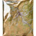
![[Product front view showing all components]](https://www.akvex.store/wp-content/uploads/2026/06/857a3afe5e7d43db91af6ac0c16981c5.jpg)
Usage
This trail map excels in a variety of outdoor scenarios. Whether you are embarking on a day hike through alpine meadows, navigating a multi‑day backpacking loop across rugged mountain passes, or planning a technical climb that requires precise elevation data, the map provides the essential information needed to make informed decisions. Its waterproof and tear‑resistant qualities allow it to withstand sudden weather changes, from light drizzle to heavy downpours, without compromising readability.
For families and groups exploring national parks, the map serves as a shared reference point, enabling coordinated navigation and safety planning. Campers can locate water sources, assess campsite suitability, and identify potential hazards such as steep cliffs or avalanche-prone slopes. The inclusion of GPS coordinates means that users can sync the map with digital devices, creating a hybrid navigation system that combines the reliability of paper with the convenience of electronic waypoints.
In addition to recreational use, the map is a valuable tool for search and rescue teams, land managers, and environmental researchers who require accurate topographic data. Its compact size allows it to be carried in emergency kits, while the detailed trail information supports rapid route planning during time‑critical operations. The map’s durability ensures that it remains functional even after repeated handling in demanding field conditions.
Why Choose Us
Outdoor Trail Maps LLC has built its reputation on a foundation of meticulous cartographic research, high‑quality printing, and a commitment to customer satisfaction. Each map undergoes a rigorous quality assurance process that includes proofing for color fidelity, verification of scale accuracy, and testing for water resistance. This dedication to craftsmanship results in a product that not only meets but exceeds the expectations of serious outdoor enthusiasts.
Our maps are produced using environmentally responsible inks and paper sourced from sustainable forestry practices. By choosing our product, you support a supply chain that minimizes ecological impact while delivering a durable, long‑lasting navigation aid. The brand’s focus on continuous improvement means that future editions will incorporate user feedback, trail updates, and technological advancements, ensuring that you always have the most reliable information at your fingertips.
Customer support is a cornerstone of our service philosophy. Should you have questions about map features, need assistance interpreting symbols, or require replacement parts, our knowledgeable support team is available to provide prompt, helpful guidance. We also offer a satisfaction guarantee, allowing you to return the map within a specified period if it does not meet your expectations, reinforcing our confidence in the product’s quality.
Key Features
- Compact 4 × 7 inch pocket size makes it easy to carry on any hike or backpacking trip.
- Waterproof and tear‑resistant construction ensures the map remains readable in wet or rugged conditions.
- 1:60,000 scale provides detailed topographic information for precise navigation and route planning.
- GPS coordinates and segment mileage enable seamless integration with digital devices and accurate distance tracking.
- Dedicated customer support and a satisfaction guarantee give you confidence in your purchase.
FAQ
What is the difference between this map and a standard road map?
This map focuses on natural terrain, trail networks, elevation changes, and outdoor features rather than roads and urban infrastructure. It provides detailed topographic contours, trailhead locations, and GPS coordinates, which are essential for backcountry navigation but not typically found on road maps.
Can I use this map with a GPS device?
Yes. The map includes precise latitude and longitude coordinates for trailheads, junctions, and key landmarks. You can input these coordinates into any standard GPS unit or smartphone app to create waypoints that correspond directly to the paper map, allowing a hybrid navigation approach.
Is the map updated regularly?
The edition you receive reflects trail data up to the 2018 season, incorporating the latest changes in trail routing, new paths, and revised distances. Outdoor Trail Maps releases updated editions periodically, and customers can purchase newer versions as they become available.
How durable is the waterproof feature?
The map is printed on a specially treated paper that resists water penetration. While it can withstand rain and splashes, it is not intended for prolonged submersion. In heavy rain, the map will remain legible, but we recommend storing it in a dry pouch when not in use.
What if I receive a damaged map?
We stand behind the quality of our products. If your map arrives torn, water‑damaged, or otherwise defective, please contact our customer service within 30 days of receipt. We will arrange a replacement or refund according to our satisfaction guarantee policy.


Reviews
There are no reviews yet.